O Φορέας Διαχείρισης Λίμνης Παμβώτιδας Ιωαννίνων ενσωματώθηκε στον Οργανισμό Φυσικού Περιβάλλοντος και Κλιματικής Αλλαγής (Ο.ΦΥ.ΠΕ. Κ.Α.) σύμφωνα με την υπ’ αριθμ. ΥΠΕΝ/ΔΝΕΠ/9236/400/2-2-2022 απόφαση (ΦΕΚ 517/Β/9-2-2022)
Η ιστοσελίδα της νέας Μονάδας Διαχείρισης Προστατευόμενων Περιοχών Ηπείρου είναι διαθέσιμη στον ακόλουθο σύνδεσμο:
https://necca.gov.gr/mu-epirus
Η παρούσα ιστοσελίδα του πρώην Φορέα (https://www.lakepamvotis.gr) πλέον δεν ενημερώνεται και παραμένει για αρχειακούς λόγους.
Επικοινωνία: mdpp.epirus@necca.gov.gr
Natural Environment and Climate Change Agency (NECCA) incorporated Lake Pamvotis Management Body, due to MD ΥΠΕΝ/ΔΝΕΠ/9236/400/2-2-2022 (GG 517/Β/9-2-2022)
The website of Management Unit of the Protected Areas of Epirus is available at the following url:
https://necca.gov.gr/mu-epirus
The present website of the ex-Management Body (https://www.lakepamvotis.gr) is not currently updated and remains live for archival purposes.
Contact: mdpp.epirus@necca.gov.gr
The urgency of implementation of a system for the evaluation of the ecological status of the protected area’s ecosystems, as well as the assessment of the conservation status of its biodiversity, entails the integration of monitoring systems as required by the Habitats Directive, the Directive on wild birds and the water Directive.
In addition, it is absolutely essential and extremely important the exchange of information and of scientific data from the implementation of long term monitoring programmes in order to make data comparisons and correlations, aiming to the improvement of the level of knowledge about the state of the lake’s ecosystem.
Monitoring is a structured observation and data collection process (measurement), repetitive and everlasting. Monitoring is also a key component of a recurrent management cycle.
As a result, monitoring includes systematic scientific research (everlasting for a specific purpose), such as the abundance of species and their geographic distribution or quality of the waters. The acquired knowledge is useful both for the understanding of what we are expected to manage and for the evaluation of results of the implemented measures.
During the period 2010 -2011, the Management Body of Pamvotis Lake has conducted a water sampling programme (laboratory and field tests), with the collaboration and support of the State Chemical Laboratory of Ioannina and the Water Department of the Decentralised Administration of Epirus. The water samples were analysed for concentration of total phosphorus (TP) and total Nitrogen (TN). Meanwhile, with the assistance of the University of Western Greece and the provision of equipment from the university, laboratory analysis of chlorophyll (chl-a) and of physicochemical parameters, has been conducted in the field (in situ) with a multimeter instrument.
The main objective of the monitoring programme was the evaluation of the quantitative assessment of Pamvotis Lake’s eutrophication. A large number of studies and works have been produced with data collected in the field regarding the quantitative assessment of the Pamvotis Lake’s eutrophication. However, it hasn’t been reported a synthesis method of the field data, so as to obtain an overall efficiency map of the measured parameters.
Between 10:00 - 12:00 in the morning, for a period of one year (June 2010 - May 2011), 48 samples (to cover all seasons) of lake water were collected and analysed for chlorophyll (Chl-a), total phosphorus (TP), total nitrogen (TN), dissolved oxygen (DO), temperature, pH, redox potential (ORP), conductivity and average transparency (Secchi disk). At the same time, the spatial and temporal distribution of the above parameters was depicted in thematic maps. The sampling frequency was 1 time/per month.
Samples of water, used for the elaboration of this research were taken from four stations in Pamvotis Lake.
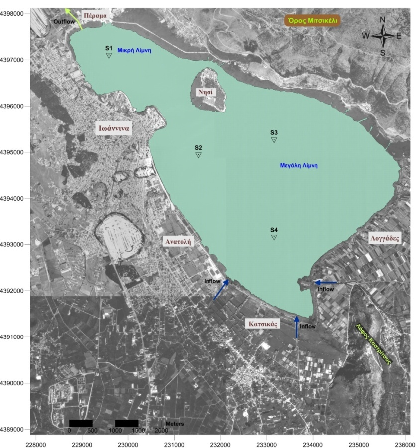
Sampling area
Station S1: Is located within the small lake, especially in the north-western part of the Lake, in the area of Perama, near to the outflow exit of the lake.
Station S2: : Is located near the region named “Dodeka”, between the city of Ioannina and the Island. The above point was chosen because it seems to gather the majority of rain water.
Station S3: Is located in the centre of the big lake, in one of the deepest points. No specific activities have been identified at this point.
Station S4: Is located in the southeast side of the lake near the Municipal Community area of Katsikas. This point was chosen, because of agricultural and rural activities developed in the area. At the same time, this position is the meeting point of the two main streams in the region.
For the selection of these four points were taken into account all those factors, which give to these areas specific features, with respect to the degree of pollution.
The summary results of the survey is here (only in Greek):